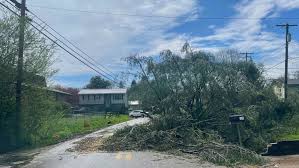
Severe weather sweeps through the Ohio Valley, with tornadoes reported in several states. Kentucky declares a state of emergency as structures sustain damage, but no fatalities are reported. Millions remain under tornado watch as the storm moves eastward, affecting multiple states and prompting safety warnings.

[ad_1]
Thunderstorms, large hail and strong winds swept through the Ohio Valley on Tuesday, bringing large hail, uprooting trees and flipping mobile homes, officials said.
On Tuesday evening, there were reports of tornadoes in Illinois, Tennessee, Ohio and in Kentucky, according to the National Weather Service. Earlier, there was one storm-related death in Oklahoma, the Tulsa Police Department confirmed, but it did not immediately provide further details.
Ohio and Kentucky, and parts of Indiana, West Virginia, Tennessee, Alabama, Mississippi and Georgia, were expected to be affected by the severe weather on Tuesday afternoon and evening, officials said. Forecasters predicted several tornadoes, damaging winds that could reach hurricane-force level, and even hail as large as baseballs.
The severe weather was part of a powerful storm system that was moving east after hitting parts of Missouri, Oklahoma and Texas on Monday evening.
More than 9 million people remained under a tornado watch as of 10:30 p.m. on Tuesday, according to weather officials. A number of schools in Tennessee either had closed or sent students home early on Tuesday, and some canceled after-school activities, according to local media reports.
About 255,000 customers were without power as of late Tuesday, with the majority of those outages in West Virginia, where more than 113,000 customers were without electricity, according to Poweroutage.us. The other states where customers were experiencing outages were Wisconsin, Michigan, Ohio and Kentucky.
Parts of West Virginia, Kentucky and Ohio were placed under a tornado watch until 2 a.m. on Wednesday, according to the National Weather Service.
Kentucky declared a state of emergency on Tuesday because of the weather.
“We have reports of substantial damage to a number of structures — and, thankfully, as of right now, we are not aware of any fatalities,” Andy Beshear, the governor, said in a statement. “We need all Kentuckians to stay weather-aware as we brace for more severe weather throughout the afternoon and evening.”
Flooding was also possible through the evening, forecasters said.
Weather officials encouraged people living in areas where a tornado watch is escalated to a tornado warning to move to a safe place, “ideally in a basement or interior room on the lowest floor of a sturdy building.”
Forecasters on Monday had also faced an outage that affected a key part of the nation’s weather tracking system, potentially making it harder for them to warn people about the severe weather. The service had returned to normal by 6:30 a.m. Eastern time on Tuesday.
Forecasters expected the storm system to move into New England on Wednesday and Thursday. More than five million people were under a winter storm warning on Tuesday afternoon, many of them in New England, according to forecasters. Boston will likely face heavy rain, river flooding, wet snow and strong winds on Wednesday and Thursday.
[ad_2]
Source link


