Introduction
Hurricane Lee, a force of nature to be reckoned with, has begun its journey towards intensification, looming as a potential Category 4 storm. In this article, we will delve into the details of Hurricane Lee’s development, its potential impacts, and the factors contributing to its growing strength.
Understanding Hurricane Lee
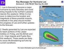
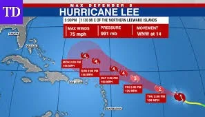
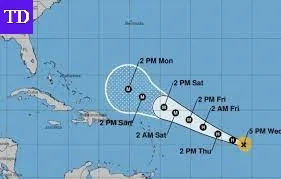
Hurricane Lee, under the watchful eyes of meteorologists, has exhibited signs of rapid intensification. According to the National Hurricane Center (NHC), this meteorological phenomenon is expected to transform Lee into a major hurricane by Friday morning. As it progresses, Lee’s path is set to take it north of the Leeward Islands and Puerto Rico, with a possibility of slowing down east-northeast of the Bahamas over the weekend.
The Factors at Play
Oceanic Energy Boost
One key factor fueling Hurricane Lee’s growth is the warm tropical ocean waters in the Atlantic. Computer models are aligning in their predictions, suggesting that these ideal atmospheric conditions will propel the storm to Category 4 or even Category 5 intensity by Saturday morning.

Winds on the Rise
As of 5 am Thursday ET, Hurricane Lee’s maximum sustained winds had already reached 80 mph. Positioned approximately 965 miles east of the northern Leeward Islands, it was moving west-northwest at a brisk 13 mph. The intensity of these winds is a strong indicator of the storm’s potential.
The Track and Its Uncertainties
A Delicate Path
Given Hurricane Lee’s expected strength, tracking its path becomes crucial. The NHC’s current forecast indicates that it will remain far enough north of the Leeward Islands and Puerto Rico to avoid significant impacts. However, the uncertainty lies in the typical track errors seen this far in advance.

Warm Waters as a Catalyst
Lee is set to traverse record-warm waters, with temperatures exceeding 86°F east of the Lesser Antilles. This favorable condition should allow the hurricane to rapidly intensify, potentially reaching the high-end of the Saffir Simpson intensity scale.
Rapid Intensification
The forecast is bold, suggesting that Hurricane Lee could transition from a Category 1 to a Category 4 storm in a mere 72 hours. Multiple bursts of rapid intensification may occur during this period, a phenomenon increasingly associated with sea and air temperature rises due to human-caused climate change.
The Future Path
Awaiting Clarity
Lee’s path beyond the early days of the next week remains uncertain. Computer models hint at a slowdown and a northward turn, influenced by various weather features, including a high-pressure area and the jet stream’s movements. These factors could potentially bring the hurricane closer to the East Coast.
Preparedness Matters
While it’s still about a week to 10 days away from potentially affecting the U.S. mainland, preparations are crucial. The forecast for Hurricane Lee will likely see refinements, emphasizing the importance of vigilance and readiness.
Conclusion
As Hurricane Lee intensifies and its trajectory unfolds, the question of its direct impact on the mainland U.S. remains unanswered. The coming days will undoubtedly be marked by heightened scrutiny and a meticulous analysis of Lee’s every move.
Frequently Asked Questions (FAQs) Of Hurricane Lee
1.What is rapid intensification in hurricanes?
Rapid intensification refers to the phenomenon where a hurricane’s maximum sustained winds increase significantly in a short period, typically 24 hours or less. This can lead to a rapid escalation in the storm’s strength.
2.Are hurricanes becoming stronger due to climate change?
Yes, studies suggest that as sea and air temperatures increase due to human-caused climate change, hurricanes are more likely to undergo rapid intensification and become stronger.
3.How are hurricane paths predicted?
Meteorologists use computer models, historical data, and real-time weather information to predict hurricane paths. However, these predictions can have uncertainties, especially several days in advance.
4.What is the Saffir Simpson intensity scale?
The Saffir Simpson intensity scale is a system used to categorize hurricanes based on their maximum sustained wind speeds. It ranges from Category 1 (weakest) to Category 5 (strongest).
5.How can I stay informed about Hurricane Lee’s progress?
To stay updated on Hurricane Lee’s developments, regularly check official sources like the National Hurricane Center (NHC) and local weather authorities. They provide real-time information and safety recommendations.


